
Facility type: FIXLAB
Access provider: Laboratory of Geophysical Satellite Remote Sensing and Archaeoenviornment (GeoSat ReSeArch), IMS, FORTH
Title: Satellite/Aerial Remote Sensing
Description
The Laboratory of Geophysical – Satellite Remote Sensing & Archaeo-environment (GeoSat ReSeArch) of the Institute of Mediterranean Studies (IMS-FORTH) is applying satellite/aerial remote sensing techniques and advanced image processing methodologies for the identification, monitoring, preservation and management of the cultural resources. Satellite remote sensing and Geographical Information Systems (GIS) through the development of sophisticated models and algorithms offer new perspectives in archaeological research and management of cultural heritage sites. Innovative satellite sensors of high spatial and spectral resolution, along with the use of high accuracy Unmanned Aerial Vehicle (UAV) imageries, Global Positioning (GPS) systems and enhanced image processing systems offer great possibilities of earth observation and space technologies for mapping archaeological sites and leading to better understanding of their evolution through the years. The Lab also conducts geoinformatics research for the environmental resources, including geological, hydrogeological and geomorphological mapping, natural hazards assessment, land use & land cover change detection analysis and other earth and environmental sciences applications. Processing of the remote sensing and geographical data is followed by the production of qualitative thematic maps which represent all the derived information through geoinformatic procedures. The gathered datasets and interrelationships associated with environmental and cultural heritage aspects offer interdisciplinary knowledge and solutions to be acknowledged by local authorities and decision makers.
Services
- Geological, geomorphological and archaeological sites mapping through remote sensing satellite imagery techniques.
- Management of natural and cultural resources.
- Imagery analysis & enhancement, mosaicking, segmentation, classification.
- Digital Terrain Elevation Data, Orthoimages, 3-D.
- Geographic Information Systems. Thematic maps.
- Land use, land cover and temporal change detection analysis.
- Urban planning, forestry, agriculture, environment.
- Coastal surveys and coastal erosion.
- Water management. Hydrography. Water pollution studies.
- Development of multi-criteria decision analysis (MCDA) approaches for the solution of earth & environmental science problems and protection/conservation of cultural heritage.
- Natural hazards and risk assessment analysis regarding flooding, erosion, landslide, urbanization and earthquake hazard scenarios using geoinformatics modelling and remote sensing.
- Cultural Resources risk assessment to natural and anthropogenic hazards.
- Archaeological landscape and prediction modelling analysis using GIS and remote sensing approaches. Settlement patterns.
- Geoheritage evaluation. Protection areas. National parks and preservation sections.
- Differential Global Position System (DGPS) and Real-Time Kinematic (RTK-GPS) data capture surveys for the creation of maps and cartographical products of archaeological sites and geological needs.
Technical Info
“Archaeological remains can be identified using crop marks based on temporal analysis satellite imageries. Various vegetation indices (e.g. NDVI, SAVI etc) and spectral signatures can be used in order to investigate such crop marks, as the reflectance properties of the vegetation are influenced by the soil conditions. Remote sensing can be useful to the detection and evaluation of a large number of soil properties (e.g. soil moisture, soil texture, iron oxides etc ) that can be related with stress vegetation due to archaeological remains buried under the soil surface.
An archaeological landscape can be analyzed in terms of its topographical characteristics. In association with the historical period and ancillary information that characterize the nature of a settlement development (whether it was used for defensible purposes or accessibility to arable land etc), Digital Elevation Models (DEMs) and its associated derivatives can be applied in order to determine the various topographical and geomorphological characteristics being predominant in the surrounding environment of a settlement. That derived information can initiate the comprehension of a settlement’s sustainability through the years and importance of their strategic location. Geographical Information Systems (GIS) can manipulate through diverse models the various derived information in a way to start understanding interrelationships of the settlement’s position in space with the topography and other nearby settlements in terms of trading, accessibility to arable land and water resources. Apart from those interrelationships GIS can use all the spatially existing information within prediction models in order to highlight the suitability of potential unknown settlements with similar characteristics and help archaeologists with new findings.
In general, the use of Remote Sensing & GIS- as a technology and as a tool- can be useful to integrate diverse digital collections and information, present their content in one space and provide through models such as a Multi-Criteria Decision Analysis (MCDA) procedure, the final products that interrelate all the acknowledged digital sources. That can provide with useful answers the archaeologists and other scientific fields to decision making.
The GeoSat ReSeArch lab equipment to meet the Satellite/aerial remote sensing applications in cultural heritage (CH) are:
UAV characteristics: Drone DroidWorkX CX-4
GPS characteristics: Triumph Javad RTK / Leica GS20 / Τhales / Ashtech Z12 Geodetic Station GPS / HEPOS
Remote sensing/GIS software’s:
- ArcGIS package
- ERDAS IMAGINE
- PhotoSCAN
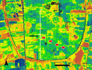
Examples/Photos
|
|
Related Publications
- Agapiou A., Lysandrou V., Alexakis D.D., Themistocleous K., Cuca B., Argyriou A., Sarris A., Hadjimitsis D.G. (2015). Cultural heritage management and monitoring using remote sensing data and GIS: The case study of Paphos area, Cyprus. Computers, Environment and Urban Systems, 54, pp. 230-239.
- Agapiou A., Alexakis D.D., Simon F.X., Kalayci T., Papadopoulos N., Sarris A., Hadjimitsis D.G. (2015). Extraction of archaeological information using high resolution FormoSAT-2 data. International Journal of Heritage in the Digital Era, Vol 4, Issue 3-4, pp. 242-255.
- Agapiou A., Sarris A. (2018). Beyond GIS Layering: Challenging the (Re)use and Fusion of Archaeological Prospection Data Based on Bayesian Neural Networks (BNN). Remote Sensing, 10, 1762, pp. 1-22.
- Argyriou V.A., Sarris A., Teeuw R. (2016). Using geoinformatics and geomorphometrics to quantify the geodiversity of Crete, Greece. International Journal of Applied Earth Observation and Geoinformation, 51, pp. 47-59.
- Sarris A., Dederix S., (2014). GIS for Archaeology & Cultural Resources Management in Greece. Quo Vadis?. In book: Proceedings of the 3rd Conference Arch_RNT on Archaeological Research and New Technologies, pp . 7-20.
- Donati J., Sarris A. (2016). Evidence for Two Planned Greek Settlements in the Peloponnese from Satellite Remote Sensing. American Journal of Archaeology 120(3), pp. 361-398.