
Bathymetric survey of the Venetian Port of Rethymnon, 2019
Laboratory of Geophysical Satellite Remote Sensing and Archaeoenvironment, IMS-FORTH, in collaboration with the Rethymnon Port Authority and the Ephorate of Maritime Antiquities – Branch of Crete.
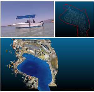
In the autumn of 2019, a survey was organized to determine the bathymetry in the Venetian Port of Rethymno in the framework of cooperation with the Rethymno Port Authority and the Ephorate of Maritime Antiquities. The depth gauge was attached to the boat through a special metal structure and connected to a positioning unit. Figure 3 shows the bathymetric model of the harbor as obtained from the processing of the data collected with the sonar with a depth ranging from 0 to 5.5 meters.
Raman spectroscopic analysis of Minoan stone objects from the Port of Messara, 2019
Lab of Photonics for Heritage Science (PHOtonics for Heritage Science-PhoHS), IESL-FORTH, in collaboration with the Archaeological Museum of Heraklion (Archaeologist – Researcher G. Flourda).
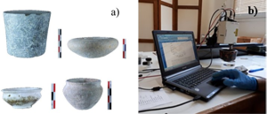
Archaeologist (G. Flouda) from the Archaeological Museum of Heraklion, in collaboration with researchers from the PhoHS laboratory, carried out analyses on stone objects of the Minoan period from the Portis area in the Mesara plain (Crete) using a portable Raman system.The measurements were carried out in the premises of the Archaeological Museum of Heraklion during the period. A total of 59 objects classified between the Early and Middle Bronze Age were studied. The Raman spectroscopic technique led to the accurate characterization of the main minerals for most of the analyzed objects. The advantages of the method are the non-invasiveness as well as the speed in carrying out the measurements. Also, the measurements are performed directly on the object and at different points on its surface to check the possible heterogeneity of the minerals. Analytical information is extracted from both crystalline and amorphous materials. The results of the present study reinforce and extend the knowledge previously gained from the examination of objects by optical microscopy. Indicatively, through Raman spectroscopy, calcium carbonate (CaCO3) in the form of calcite was detected, associated with the existence of marble or limestone. Minerals such as steatite, dolomitic limestone, and serpentinite were also identified.
The results of the study were published in the Journal of Archaeological Science: Reports DOI: 10.1016/j.jasrep.2020.102436
Investigation of coastal erosion in Gra Lygia, Ierapetra, 2020
Laboratory of Coastal & Marine Research, IYM-FORTH in collaboration with the Regional Unit of Lassithi, Crete.
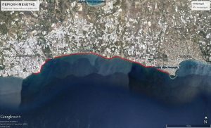
In the autumn of 2020, measurements were performed, using all the instruments of the laboratory of Coastal & Marine investigations, in the area of Gra Ligia Ierapetra, during which data collection from the coastal area was carried out.
This effort aimed to analyze coastal erosion issues while also contributing to the protection of a submerged monument, believed to be a Roman villa. Located at a depth of -2 to -4 meters, this ancient structure offers a compelling link to the region’s historical past.
Analysis and identification of pigments in the Minoan “Swallows’ Wall Painting”, 2019
Laboratory of Photonics for Heritage Science (PHOtonics for Heritage Science-PhoHS), IESL-FORTH, in collaboration with the Ephorate of Heraklion Antiquities (Archaeologist – Researcher M. Roussaki).
In the spring of 2019, in the context of the study of the Minoan mural of Chelidonionia, the Archaeologist – Researcher M. Roussaki, of the Ephorate of Antiquities of Heraklion was given access to the laboratory infrastructure of the IESL (portable equipment and laboratory instruments) to analyze the pigments and the mortar of the mural. The “Mural of the Swallows” was discovered during a rescue excavation in the modern settlement of “Bougada Metochi” of Knossos, on a plot of land about 350 meters west of the central courtyard of the palace of Knossos, in a chronological context of the Palaeopalatial period (according to the ceramic evidence). A small number of preserved fragments indicate that the fresco depicts swallows in a rocky landscape, the first swallows so far identified with certainty in Minoan painting.
Study of a 17th-century elephant tooth sample, 2019
Lab of Ancient DNA, IMBB-FORTH, in collaboration with the University of Lisbon.
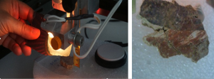
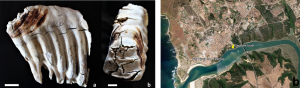
In collaboration with the University of Lisbon, a 17th-century elephant tooth specimen found in southwestern Portugal (Figure 6) was studied to identify the species to which it belongs and to determine the country of origin. This study led to the writing of a scientific paper entitled “Molecular identification and geographic origin of a post-Medieval elephant finding from southwestern Portugal using high-throughput sequencing” which was recently accepted for publication in the journal Scientific Reports.
Mapping of the Mycenaean cemetery at Prosilio in Boeotia, 2017
Laboratory of Geophysical Satellite Remote Sensing and Archaeoenvironment, IMS-FORTH, in collaboration with the Ephorate of Antiquities of Boeotia and the British School of Athens/Cambridge University.
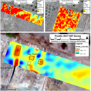
The excavation activities carried out in the summer of 2017 at Prosilio, Boeotia, brought to light a monumental Mycenaean stone chamber tomb, which is one of the largest of its kind ever discovered in Greece. As part of this, the Laboratory undertook extensive geophysical mapping in the area using 3D electrical tomography. The results of the geophysical survey were able to indicate several candidate conductive targets associated with the soil material of the roads leading to known or potential thalamic graves. In addition, the geophysical survey verified the existence of a new grave.