Facility type: MOLAB
Access provider: Coastal & Marine Research Lab, IACM, FORTH
Title: Coastal & Underwater Survey
Description
Includes all portable marine survey methods and equipment (e.g. Drones, ROV, wave & tide sensors, side scan sonars, diving equipment). Activities of the Lab aim to provide a detailed description of the surrounding environment in which the cultural heritage site is located. Moreover to identify the specific characteristics of the site in terms of geometry and building materials. The equipment of the Lab and also be used for the survey and identification of possible new sites and also monitoring of sites.
Services
- Large Scale Oceanographic and geomorphological surveys of underwater Archaeological Sites
Technical Info
- Phantom 4 Pro V2.0:
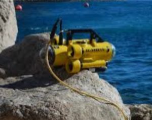
Featuring a 1-inch CMOS sensor that can shoot 4K/60fps videos and 20MP photos. OcuSync 2.0 HD transmission system with five directions of obstacle sensing. The onboard camera features a 1-inch 20MP CMOS sensor and a mechanical shutter. An optimized f/2.8 wide-angle lens. - Guardian Mini-ROV :
This Mini-ROV is a 150m depth rated ultra-portable underwater inspection robot equipped with 4 horizontal and 1 vertical thruster. Fitted with 2 high-resolution color video cameras, one on pan&tilt, and LED lighting, it has been especially designed for long range missions (> 400m). - Diving equipment
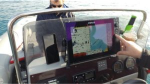
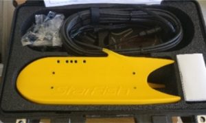
Examples/Photos
|
|
|
|
Related Publications
- Alexandrakis, George, Georgios V. Kozyrakis, and Nikolaos Kampanis. “Interventions on Coastal Monuments Against Climatic Change.” International Conference on Transdisciplinary Multispectral Modeling and Cooperation for the Preservation of Cultural Heritage. Springer, Cham, 2018.
- Rempis, Nikolaos, George Alexandrakis, and Nikolaos Kampanis. “Human induced coastal changes and their impact on the coastal urban landscape. The case of Heraklion, Crete.” EGU General Assembly Conference Abstracts. Vol. 19. 2017.
- Alexandrakis, George, and Nikolaos Kampanis. “Coastal Vulnerability and risk assessment of infrastructures, natural and cultural heritage sites in Greece.” EGU General Assembly Conference Abstracts. Vol. 18. 2016.
- Alexandrakis G, Kampanis N.A., Pouli P., and Sythiakakis V., (2016) Climate changes impact of Cultural heritage sites. Risk management and mitigation. Sustainable knowledge and preservation of Cultural Heritage for future generations – Risk management EMRS Spring Meeting 2/5-6/5 2017 Lille France
- Alexandrakis, G., Athanasaki, K. & Kampanis, N.A. (2016) Towards a GIS-based reconstruction of a coastal landscape, integrating geomorphological and archaeological evidence. 2nd Computer Applications and Quantitative Methods in Archaeology-GR. Conference 21-22/12/2016