
Facility type: MOLAB
Access provider: Laboratory of Geophysical Satellite Remote Sensing and Archaeo-environment(GeoSat ReSeArch) – IMS
Title: Photogrammetry and 3D Laser Scanner in cultural heritage
Description
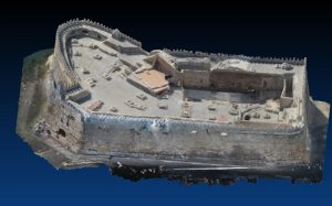
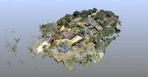
Photography provides a simple but important integral tool to record and document the archaeology and cultural heritage and in later stages to plan strategies for conservation or reconstruction. To this direction, photogrammetry makes a step forward in extracting metric information from a single or preferably a set of photographs. A series of multiple images taken from the same camera and different angles can be photogrammetrically processed to determine the exact location from which these photos were taken and interpolate 3D shapes of depicted objects. The use of measured ground control points in a local or global geographic coordinate system is essential. Essentially photogrammetry translates historical or modern 2D photographs in three dimensional clouds thus imaging cultural landscape and archaeological artefacts. The extracted 3D information can be further processed in an effort to compile new data and 3D representations of the threatened objects enhancing the information context of archaeological research looking details beneath design r texture and creating replicas of specific artifacts.
Terrestrial Laser Scanning extracts distances and angles between the sensor and the object or the surface. Its functioning is largely based on speed-of-light by sending out hundreds of thousands of light pulses and measuring the distance between its location and objects the light pulses hit. Most recent scanners are capable of measuring almost completely the area around them (usually with a field of view (FOV) of 360° by 220-270°) up to some hundred meters and generate a dense cloud of 3D points in given unit measure. Processing software accompanying the scanner normally provides the possibility to align and merge multiple point-clouds, so that a single object, scanned from different perspectives, can be completely documented. In terms of output, TLS and digital photogrammetry produce similar information. If the laser scanner is equipped with a digital colour camera, it is usually capable of generating color-coded point clouds and a panoramic image, result of seamless un-distortion and merging of individual still pictures.
Services
- Recording of historic buildings, artefacts, and monuments
- Monitoring of historic buildings, archaeological sites, or geological aspects.
- Compilation of architectural drawings of artefacts, monuments
Technical Info
Leica Total Station TC307
Leica Total Station TS06 plus R500
Faro Focus 3D X330 Terrestrial Laser Scanner & Faro Scene 7.1.1.8
Kinect Sensor XBOX ONE
Oculus Rift Development Kit 2
Canon EOS 350D, Canon Lens 18-55mm for 350, Canon EOS 5D Mark ii, Canon Lens Ultrasonic 28-13, Olympus camedia c-5060, photographic digital cameras
Sony Digital Video Camera, Sony handy Cam, Panasonic HC-V550EG Digital Video Camera Recorder
Examples/Photos
|
|
|
Related Publications
- Photogrammetric 3D documentation of Cultural Heritage: the Venetian Castle at Heraklion, Crete (Greece). In The future of the past: from Amphipolis to Mosul. New approaches to cultural heritage preservation in the Eastern Mediterranean.
- Cantoro, Gianluca. Aerial Reconnaissance in Archaeology – from Archives to Digital Photogrammetry, in (A. Sarris ed.) Best Practices of GeoInformatic Technologies for the Mapping of Archaeolandscapes (ISBN: 9781784911621), 103-114
- Cantoro, Gianluca, and Apostolos Sarris. 2012. Fundamental Tools for Photo-Interpretation in Mountainous Rocky Areas: Photogrammetry and Ground-Truthing. In Proceedings of the 32nd EARSeL Symposium, 100–112. Mykonos, Greece.
- Cantoro, Gianluca. 2012a. A free set of tools for automated imagery rectification. International Society of Archaeological Prospection (ISAP) 30: 9–11.