
Facility type: MOLAB
Access provider: Laboratory of Geophysical Satellite Remote Sensing and Archaeo-environment (GeoSat ReSeArch), IMS, FORTH
Title: Subsurface geophysical mapping and imaging
Description
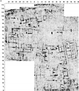
The GeoSat ReSeArch Lab conducts small and large scale inland and shallow offshore geophysical surveys of cultural heritage sites for mapping and imaging the subsurface or submerged archaeological relics and increase the efficiency of future excavation activities. The Lab is also involved in research of the environmental consequences of technical construction works, environmental pollution, and for geological, hydrogeological and geotechnical mapping. The Lab uses the most modern and precise equipment for fieldwork activities, sophisticated computer facilities, and software for processing, interpreting and visualizing the geophysical data. Geophysical investigations include the use of handheld and multisensor fluxgate gradiometers, soil resistivity methods, single and multifrequency conductivity techniques, electrical resistivity tomography, ground penetrating radar with single multichannel of antennas, magnetic susceptibility measurements, seismic methods, and Global Positioning Systems. A geophysical prospection project consists of the planning and fieldwork phases and the subsequent data analysis, processing, interpretation phase in the lab. The technical support of the Lab includes the mapping of large areas with a dense sampling interval, which is usually specified depending on the needs of the survey and the land cover. In this way, it is possible to locate architectural remnants, wall structures, trenches, kilns, roads, firehearths, pits and other features of archaeological interest. A much more systematic approach could even estimate the depth to the archaeological features and identify the different occupation layers of a site. Processing of the geophysical data is followed by the production of maps that represent the geophysical targets of probable archaeological nature.
Services
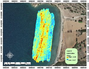
- Near-surface mapping of the inland and shallow off-shore archaeological sites with the aim to guide excavations or surface surveys, locate and map archaeological remnants and estimate the wider area of archaeological interest.
- Estimation of depth to the archaeological relics and verification of the occupation layers.
- Magnetic properties of the archaeological soils and materials.
- Planning and management of actions for the development of archaeological sites.
- Assessment of the effects of construction works in archaeological areas.
- Environmental consequences on archaeological sites, conservation areas, cultural and natural national parks.
- Imaging and monitoring the integrity of standing monuments.
- Monitoring the physico-chemical subsurface properties
Technical Info
The measurement of the magnetic field is carried out by proton or caesium magnetometers, which measure the total magnetic field strength, or by gradiometers (proton, caesium or fluxgate), which measure the vertical or the horizontal gradient of the total magnetic field or one of its components, correspondingly. The measurements of the first derivative of the vertical component (vertical magnetic gradient) are taken with a fluxgate gradiometer. Fluxgate gradiometers have accuracy of the order of magnitude of 0.1 – 1nT/m. The magnetic field is measured using a sensitive sensor at a constant distance and close to the surface of the ground. The magnetic methods are best suited for features that contrast with the surrounding soils in the concentrations of magnetic minerals they contain such as pits or ditches filled with topsoil imbedded in sub-soils. In particular, burned soils, habitation units and ditches filled with organic material enhance the magnetic susceptibility of the soil and thus are good targets for magnetic methods.
The soil electrical resistivity technique is a useful method for characterising the sub-surface materials in terms of their electrical properties. Variations in electrical resistivity (or conductivity) typically correlate with variations in lithology, water saturation, fluid conductivity, porosity and permeability, which may be used to map stratigraphic units, geological structure, sinkholes, fractures and groundwater. The technique are best suited for features that contrast with the surrounding soils in porosity, density and water content such as walls and ditches. It provides information about the horizontal and vertical distribution of the resistivity within the ground, illuminating the stratigraphic information that can be used for 3D resistivity reconstructions of the subsurface. Resistivity mapping and tomography are suitable for outlining walls, cavities, ditches, graves, tombs within an archaeological prospection survey.
Radar is the acronym for RAdio Detecting And Ranging. It is a system that uses the high-frequency electromagnetic radiation. The Ground Penetrating Radar method has the same operation principle with the seismic reflection method. This geophysical technique is applicable to strata mapping in the cases of soils and rocks and depends on the different electrical properties that various materials have. The development of the method started mainly in 1956 but accelerated considerably after 1970 as a result of the tremendous progress that took place in electronics and computer technology after 1960. A high-frequency electromagnetic radiation is transmitted in the ground and the reflected waves are recorded. The propagating electromagnetic energy in the ground depends on the subsoil’s electrical properties, the conductivity and the dielectric constant. Basically, the method depends on the record of the waves reflected on surfaces that divide regions with different electrical properties. Ground-penetrating radar (GPR) can be used in a series of applications like the mapping of the bedrock depth, the determination of the stratum thickness and the aquifer depth, the location of physical and artificial cavities in the subsurface, cracks in the bedrock and the tracing of the changes in the rocks’ composition. The method is specially used in archaeological prospection for the detection of buried antiquities (walls, architecture, tombs, graves, etc). The method cannot be used in water-saturated environments or in soils with high humidity.
Electromagnetic (EM) surveys are specially adapted to mapping lateral differences of conductivity. Possible geological targets are steep dipping structures such as faults or fracture zones. Measurements of the quadrature mode permit an estimate of the soil conductivity, whereas measurements of the in-phase mode are proportional to the magnetic susceptibility of the soil. Mostly in use are EM surveys with movable horizontal and coplanar coils. Vertically polarized sinusoidal oscillations are transmitted and received. An alternating primary field is transmitted, which induces in rocks with dissimilar electric resistivity’s eddy currents or secondary magnetic fields. These can be directed either against or parallel to the primary field, depending on whether the resistivity of the body is lower or higher than the surrounding rock or material. By interference of the primary and the secondary field, the resulting field is produced, which is finally received on the surface. Changes of the in-phase and out-of-phase (quadrature) components allow conclusions as to the positions of especially good or bad conducting underground bodies. component (or imaginary or quadrature component).
Frequently, anthropogenic soils have magnetic properties distinct from those of the background that encloses an archaeological site. Surface susceptibility variations produced by ploughing and scatters of small iron or ceramic objects can be quite easily identified. Different theories, mainly concerned with heating/burning, fermentation, and bacterial processes have been proposed to explain the phenomenon of the enhancement of susceptibility by conversion of non-ferrimagnetic forms of iron to ferrimagnetic ones. A dual frequency susceptibility sensor can be used to test the possibility of distinguishing the multi-domain grains most likely derived from natural rock, from the single-domain (larger frequency dependent) grains of soil affected by human-activity. Human activity, weathering and burning, favor the conversion of magnetic particles to a smaller size characterized by high frequency dependent susceptibility and thus measurements of the susceptibility at two or more frequencies can be used as a guide for the location of areas of archaeological interest. The “frequency dependent susceptibility can be used as a relative measure distinguishing ancient human activity from the modern one. It can provide information on the extent and dating of human occupation (stratigraphy) and even predict the potential of a site for the magnetometer survey, by examining the average level of susceptibility of the topsoil and the corresponding contrast between features and their soil context.
Geophysical Instrumentation:
• Bartington Fluxgate Gradiometers GRAD 601
• FM256 Fluxgate gradiometer
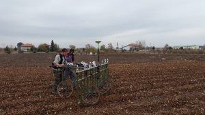
• Sensys Multi – Magnetometer Array with 16 gradiometer sensors and two carts / electronic boxes
• Sensys Multi – Magnetometer Array with 4 gradiometer sensors special cables and electronic box for shallow underwater surveys
• Geoscan RM85 Advanced resistivity meter
• GPR – NOGGINPLUS of SENSORS & SOFTWARE & GPR – EKKO1000 (3 units)
• Mala Mini Mira multi- antenna GPR (eight channel)
• Geonics EM31 MK2 Ground conductivity meter
• Geophex GEM2 Multifrequncy EM
• GF Instruments CMD Mini Explorer
• Electrical Tomography IRIS Instruments SYSCAL Pro 10 channel & SWITCH Pro 96 / cables 1m, 5m / cables with graphite and stainless steel cylinder for marine acquisition.
• Electrical Tomography IRIS Instruments SYSCAL Pro Switch 48
• Seismic Tomography/reflection PASI GEA 24-CHANNEL SEISMOGRAPH, cables, 24 4.5Hz geophones
• Lippmann 4point light 10W resistivity meter & 48 channel Switch box
• YSI Pro1030 pH/ORP/Conductivity/Temperature
• Lacoste& Romberg Model D land MicroGravity Meter (needs repair)
• Magnetic susceptibility meters Bardington ΜS3, MS2D, Bardington MS2F, Bardington probes
• Smartmag model SM-4G Caesium magnetic gradiometer
• Triumph Javad RTK / Leica GS20 / Τhales / Ashtech Z12 Geodetic Station GPS / HEPOS
• 20 High Performance WorkStations / 3 Toughbooks / 2 Toughpads / Server / 2 HP Plotters / 5 HP Printers
Examples/Photos
|
|
|
|
Related Publications
• Papadopoulos, N.G, Yi, M.Y., Kim, J-H., Tsokas, G.N., Tsourlos, P., (2010). Geophysical Investigation of Tumuli by means of Surface 3D Electrical Resistivity Tomography. Journal of Applied Geophysics 70 (2010) 192–205.
• Papadopoulos, N.G, Tsourlos, P., Papazachos, C., Tsokas, G.N., Sarris, A., and Kim, J-H., (2011) An Algorithm for the Fast 3-D Resistivity Inversion of Surface Electrical Resistivity Data: Application on Imaging Buried Antiquities. Geophysical Prospection, 59, 557-575.
• Papadopoulos, N., Tsokas, G., Sarris, A., Tsourlos, P., Vargemezis, G., (2014). Ground based archaeological prospection: Case studies from Greece. First Break, 32, 73-80.
• Moffat, I., Papadopoulos, N., Donati, J., Sarris, A., Kalayci, T., Cuenca-García, C., Cantoro, G., Argyriou, N., Armstrong, K., Kalogiropoulou, E., Manataki, M., Simon, F.X., Karapanagiotou, A.V., and Hadji-Spiliopoulou, G., Multi-component geophysical survey at the Classical Greek cities of Mantinea and Elis. Antiquity, Project Gallery articles, 345, 1-4. 2015.
• Simyrdanis, K., Papadopoulos, N., Cantoro, G, (2016). Shallow off-shore archaeological prospection with 3-D electrical resistivity tomography: The case of Olous (modern Elounda), Greece. Remote Sensing, 8, 897, doi: 10.3390/rs8110897 (http://www.mdpi.com/2072-4292/8/11/897/pdf).
• Donati, J.C., Sarris, A., Papadopoulos, N., Kalayci, T., Simon, F.X., Manataki, M., Moffat, I., & Cuenca-García, C., (2017). A Regional Approach to Ancient Urban Studies in Greece Through Multi-Settlement Geophysical Survey, Journal of Field Archaeology, DOI: 10.1080/00934690.2017.1365565.
• Kalayci, T., Simon, F-X. & Sarris, A., A Manifold Approach for the Investigation of Early and Middle Neolithic Settlements in Thessaly, Greece, Geosciences, 7:79, pp. 1-24, 201`7
Related info
https://www.ims.forth.gr/en/department/view?id=7